Cities in Manipur: Imphal, Bishnupur, Thoubal and Safety Notes
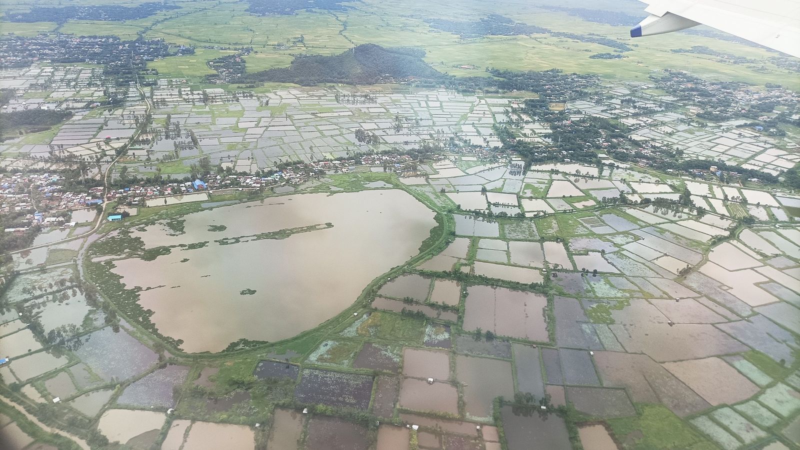
Photo: Haoreima, CC BY-SA 4.0 (cropped), via Wikimedia Commons

The Imphal valley from the hills at its edge, flat and green under a hazy winter sky.
In Manipur most of the towns a visitor can reach today lie in one oval valley, within a short drive of Imphal.
Imphal, where every trip begins
Imphal is the capital and the only city. The 2011 Census counted 277,196 people in the municipal area and its outgrowths, many times more than any other town in the state. The airport and nearly all the hotels are here.
Life in Imphal can stop at short notice for a bandh, a general shutdown called by a political or civic group. On a bandh day shops, markets and public transport close, and it is wise to stay in. On 15 October 2026, for one, a 12-hour bandh shut all three Ima Keithel markets. Leave a spare day in any plan, and ask your hotel each evening about the next day.
Bishnupur, Moirang, Thoubal and Kakching, the valley towns
Bishnupur is 27 km south of Imphal on the Tiddim Road. Its name means the abode of Vishnu, and its small brick Vishnu temple dates from the reign of King Kyamba, who ruled from 1467 to 1506. It is the only monument in Manipur protected by the Archaeological Survey of India. Further south, Moirang is the town for Loktak Lake, with the old temple of Lord Thangjing and the museum of the Indian National Army.
South-east of Imphal, Thoubal is the second town of the valley, with 45,947 people in 2011, on the highway that runs towards the Myanmar border. Kakching, further south, had 32,138 and is a busy market town for the southern valley. Both are working towns more than sights, and easy half-day drives.
The hill towns, and the situation in 2026
The hill towns are a different matter. Since May 2023 ethnic violence between Meitei and Kuki-Zo groups has killed more than 200 people, and buffer zones still divide the valley from parts of the hills. Since February 2026 there have also been clashes between Kuki and Naga groups. On 9 and 10 October 2026, nine people were killed in Kamjong, Ukhrul and Kangpokpi districts. As of mid-October 2026, the UK government advises against all but essential travel to the whole of Manipur, including Imphal.
So Ukhrul, the Tangkhul Naga town 83 km east of Imphal, and Churachandpur, the main town of the Kuki-Zo hills in the south, are not easy places for a visitor to reach this year. Senapati, on the highway north to Kohima, is passed rather than visited. Check the news and ask a local operator before any trip into the hills, and travel only if they say the road is open and calm.
Jiribam, Mao and getting in
Most visitors fly into Imphal. Two land gateways matter too. Jiribam, a small town on the Assam border far to the west, had 7,343 people in 2011 and is where Manipur's railway begins. Mao, on the Nagaland border in the north, is the gate on the road from Kohima and Dimapur.
Any Indian visitor who is not a Manipur resident needs an Inner Line Permit. The state's portal issues temporary permits for up to 30 days, which cannot be renewed, and has counters at Imphal Airport, Jiribam Railway Station and Mao Gate. Foreign nationals need a Protected Area Permit as well.
Planning around the news
In Manipur the plan that works is a short, valley-only trip with room to change. Base yourself in Imphal, keep each day trip within the valley, and leave one spare day for a bandh or a closed road. Travel with a local operator who follows the news every day; they will know which roads are calm before any website does.
Read your government's travel advice before you book. Where it advises against travel, as the UK's does for all of Manipur in October 2026, travel insurance may not cover you. Check your policy, and carry your Inner Line Permit and photo identity at all times, since checkpoints are frequent.
Towns to know
- Imphal (Imphal West and Imphal East): the capital, 277,196 people in 2011; every trip starts here.
- Bishnupur (Bishnupur): 27 km south of Imphal, with Manipur's only ASI-protected monument.
- Moirang (Bishnupur): the lake town, for Loktak and the INA museum.
- Thoubal (Thoubal): the second valley town, 45,947 in 2011.
- Kakching (Kakching): the market town of the southern valley, 32,138 in 2011.
- Ukhrul (Ukhrul): the Tangkhul Naga hill town; check the road before you go.
- Churachandpur (Churachandpur): the main town of the southern hills; movement from the valley is restricted.
- Senapati (Senapati): a hill town on the highway north to Kohima.
- Jiribam (Jiribam): the western gateway on the Assam border, with a railway station.
For now, Manipur's towns ask for patience and a careful eye on the news, and the valley still repays both.
Plan your visit
| Best season | October to April, when the valley is dry. Lunar festivals and the November state festival can change at short notice in the current situation; check before you plan around them. |
|---|---|
| How to reach | Fly to Imphal. By road, the way in is through Mao Gate from Kohima and Dimapur in Nagaland. Jiribam, on the Assam border, has Manipur's railway station, but it is a long way from Imphal. |
| Getting around | Taxis and hired cars with drivers within the valley. Expect security checkpoints. Shops and transport stop on bandh days, so check the evening before. |
| Where to stay | Central Imphal, around Thangal Bazar and Paona Bazar, for the city and day trips; Moirang or Sendra for Loktak Lake. |
| How long to spend | Three or four days in the valley, plus a spare day. The Manipur guide has the festivals, the food and Loktak Lake. |
| Permits | Indians who are not Manipur residents need an Inner Line Permit from manipurilponline.mn.gov.in; temporary permits last up to 30 days and cannot be renewed. Foreign nationals need a Protected Area Permit from the e-FRRO portal, as of October 2026. |
Questions people ask
Can visitors go to Ukhrul or Churachandpur now?
It depends on the week. In October 2026 there was fresh violence in Ukhrul and neighbouring districts, and movement between the valley and the Kuki-Zo hills around Churachandpur remains restricted. Ask a local operator and check the news before planning any hill trip.
What is a bandh?
A general shutdown called by a political or civic group. Shops, markets and public transport close, often from dawn to dusk or for 12 hours. Visitors should stay at their hotel on bandh days and plan a spare day.
Which towns make good day trips from Imphal?
Bishnupur and Moirang to the south, on the way to Loktak Lake, and Thoubal and Kakching to the south-east. For the temples along these roads, read Manipur's temples, from Imphal to Kaina Hill.
Is there an official list of developed cities in Manipur?
No. There is no official ranking, and this guide does not make one. Imphal is by far the largest town, with most of the state's services.
Read next
Written by Muthu, editor of Aura of India. Sources: Manipur Inner Line Permit portal, Government of Manipur, Bishnupur District: Bishnupur (Vishnu temple, distance from Imphal), Press Information Bureau: Vishnu temple at Bishnupur, the only ASI-protected monument in Manipur, GOV.UK: India travel advice, warnings and insurance (updated 7 October 2026), Akashvani News: President's Rule revoked in Manipur, The Hindu: situation tense in Manipur as toll rises to nine, The Assam Tribune: Black Day bandh paralyses Imphal (15 October 2026). Last verified: 15 October 2026.
Your turn: If you have been to Imphal recently, how did you plan around bandhs and checkpoints?
Comments
Post a Comment
Comments are always welcome, that will help us to motivate ourselves and improve our services. Thanks!!