Cities in Mizoram: Aizawl, Lunglei, Champhai and Serchhip
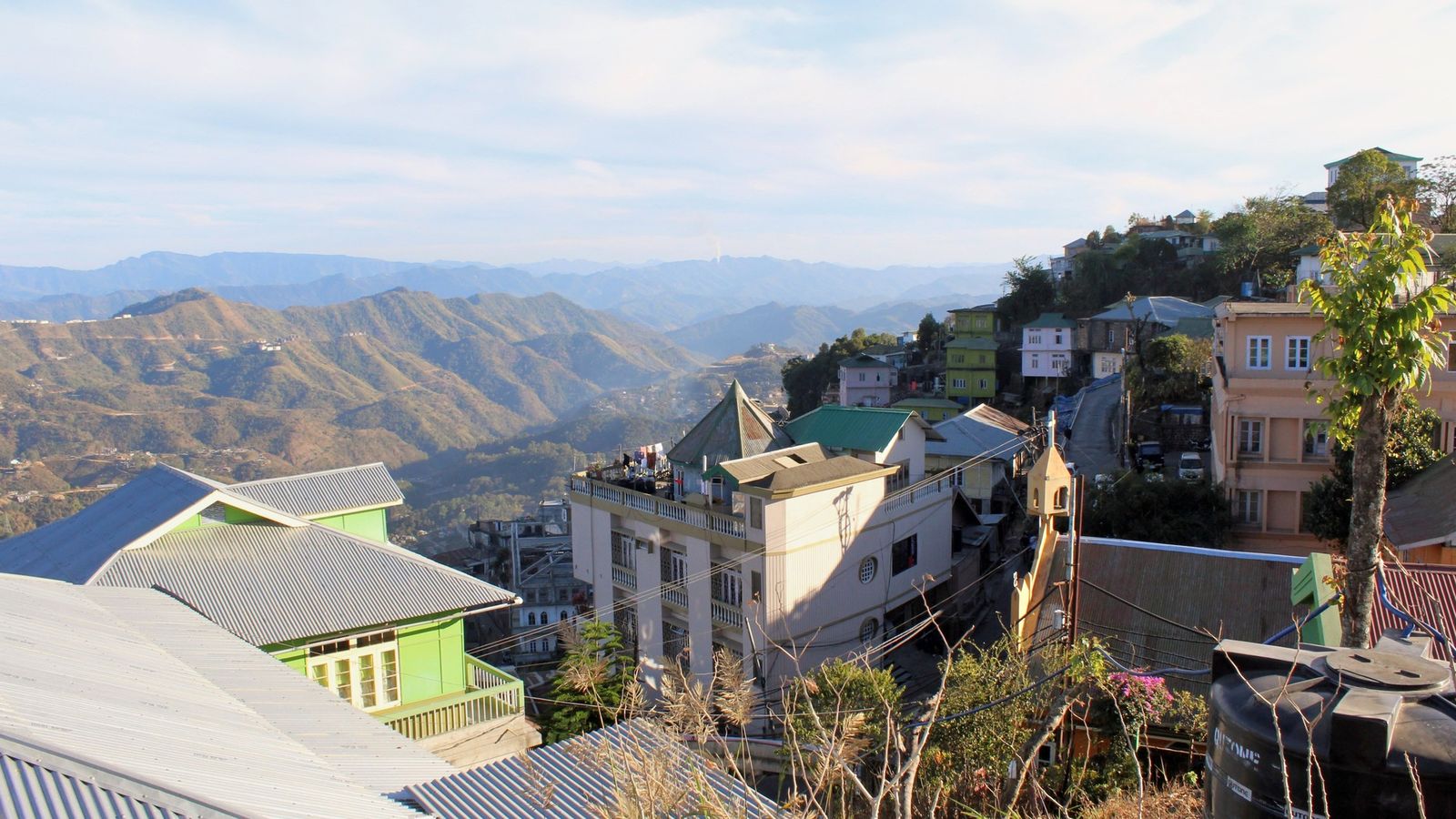
Photo: R london, CC BY-SA 3.0 (cropped), via Wikimedia Commons

Aizawl stacked down its ridge above the Tlawng valley, on a clear morning in early winter.
Mizoram has one city and a string of small hill towns, each a long ridge road from the next.
Aizawl, the one city
Aizawl is the only place in Mizoram that feels like a city. The 2011 Census counted 293,416 people there, more than a quarter of the whole state's 1,097,206. Houses and churches are stacked down steep slopes. The government, the main markets, the colleges and most of the state's rooms are here, and nearly every route in Mizoram passes through.
Lengpui Airport serves the city, and since September 2025 trains have run to Sairang, about 20 km away. Use Aizawl as a base for a few days, then choose one direction for the rest of the trip: south to Lunglei, or east to Champhai. Few visitors have time for both.
Lunglei and the long road south
Lunglei, the second town, had 57,011 people in 2011, and its district calls it Mizoram's second capital. Two roads lead there from Aizawl. The national highway through Serchhip is 235 km; the road locals call the World Bank road, through Thenzawl, is 175 km. There is no airport or railway, so the choice is a bus or a maxi cab, the local name for a shared van. Both run by day and by night.
Beyond Lunglei the state narrows towards its southern borders. Lawngtlai, with 20,830 people in 2011, is the town of the far south-west, in a district that borders both Bangladesh and Myanmar. Siaha, with 25,110, is the main town of the Mara people. Palak Dil, Mizoram's largest lake, is in Siaha district but not near the town: it lies close to Phura village, about 100 km away by road.
Champhai and the eastern border
Champhai lies 194 km east of Aizawl, a drive of five to seven hours through Seling and Khawzawl. It sits in a broad valley of rice fields, with the hills of Myanmar along the eastern skyline. Buses and Sumos, the shared jeeps of the hills, run daily except Sundays. The district also lists a helicopter service on Tuesdays and Thursdays; check before you plan around it.
The town had 32,734 people in 2011. Zokhawthar, the border village on the Tiau river, is about 27 km beyond. Rih Dil, the heart-shaped lake often listed among Champhai's sights, is across the border in Myanmar, so ask locally about the current border rules before you go. Khawzawl, 152 km from Aizawl on the same road, now heads its own district.
Serchhip, Kolasib and the way in
Serchhip, 112 km south of Aizawl on the highway, is a small district town and the turning for Thenzawl, the weaving town near Vantawng Falls. Kolasib, with 24,272 people in 2011, is the first district headquarters a driver reaches after the entry gate at Vairengte. Both make easy stops rather than destinations.
Every Indian visitor from outside Mizoram needs an Inner Line Permit, applied for online. Mizoram Tourism says it is also issued at the Mizoram Houses in six cities and on arrival at Vairengte, Farkawn, Bairabi, Kanhmun, Sairang station and Lengpui Airport. Foreign nationals have needed a Protected Area Permit since 17 December 2024; they apply on the e-FRRO portal and register online within a day of arriving.
Choosing a direction
A week in Mizoram works best as one long loop rather than two. For the south, drive from Aizawl to Lunglei by the Thenzawl road, stopping for Vantawng Falls, and come back by the highway through Serchhip. The two roads together make a circuit of about 410 km.
For the east, drive from Aizawl to Champhai through Seling and Khawzawl, with a detour to Tam Dil near Saitual, and spend two nights in the valley. Siaha and Lawngtlai need several more days and a driver who knows the southern roads.
Towns to know
- Aizawl (Aizawl): the capital, home to 293,416 people in 2011 and the start of almost every trip.
- Lunglei (Lunglei): the second town, 57,011 in 2011; 175 km or 235 km from Aizawl.
- Champhai (Champhai): a rice valley on the Myanmar border, 194 km east of Aizawl.
- Serchhip (Serchhip): a highway town 112 km south of Aizawl.
- Thenzawl (Serchhip): the weaving town near Vantawng Falls.
- Kolasib (Kolasib): the first district headquarters after the Vairengte gate.
- Khawzawl (Khawzawl): a district town on the road to Champhai.
- Lawngtlai (Lawngtlai): the far south-west, 20,830 people in 2011.
- Siaha (Siaha): the Mara town, with Palak Dil about 100 km away.
In Mizoram the way between two towns is counted in bends and hours, and the next ridge is always in view.
Plan your visit
| Best season | October to March, for dry roads and clear views east to Myanmar. Chapchar Kut, the spring festival, falls in the first week of March. May to September is the wet season, when landslides can close roads for hours. |
|---|---|
| How to reach | Fly to Lengpui Airport, or take the train to Sairang, about 20 km from Aizawl. Lunglei, Champhai, Serchhip and Siaha have no airport or railway; go on by road from Aizawl. |
| Getting around | Buses and maxi cabs (shared vans) from Aizawl to the district towns; Champhai services run daily except Sundays. Hire a car with a driver for falls, lakes and villages off the main roads. |
| Where to stay | Central Aizawl; Thenzawl or Serchhip on the southern loop; Lunglei town; Champhai town for the east; Siaha for Palak Dil. |
| How long to spend | Three days for Aizawl and the hills nearby; a week for one loop, south or east; ten days or more for Siaha and Lawngtlai. More in the Mizoram guide. |
| Permits | Indian visitors from outside Mizoram: an Inner Line Permit, applied for in advance on ilp.mizoram.gov.in, or obtained on arrival at the listed entry points. Foreign nationals: apply on e-FRRO for a Protected Area Permit, then register online within a day of arriving, as of October 2026. |
Questions people ask
Which is the second-largest town in Mizoram?
Lunglei, with 57,011 people in the 2011 Census. Its district calls it the second capital. It is 175 km from Aizawl by the Thenzawl road, or 235 km by the highway through Serchhip.
Is Aizawl the most developed city in Mizoram?
There is no official ranking of Mizoram's towns by development. Aizawl is by far the largest, with more than a quarter of the state's people in 2011, and it has the airport, the nearby railway station and most services.
Can I reach Lunglei or Champhai by train or plane?
Not directly. Both are reached by road from Aizawl, by bus, maxi cab or hired car. Champhai's district lists a helicopter service on set days; check the schedule before you plan around it.
Read next
Written by Muthu, editor of Aura of India. Sources: Office of the Deputy Commissioner, Serchhip: population of districts and towns (Census 2011), Lunglei District: How to reach, Government of Mizoram: road distances, Aizawl to Lunglei, Champhai District: How to reach, Siaha District: Pala Tipo (Lake), Environment, Forests and Climate Change Department, Mizoram: Palak Wetland, Mizoram Tourism: entry formalities for domestic and foreign tourists. Last verified: 15 October 2026.
Your turn: Did you go south to Lunglei or east to Champhai, and which road did you take?
Comments
Post a Comment
Comments are always welcome, that will help us to motivate ourselves and improve our services. Thanks!!