Cities in Nagaland: Kohima, Dimapur, Mokokchung and Mon to Visit
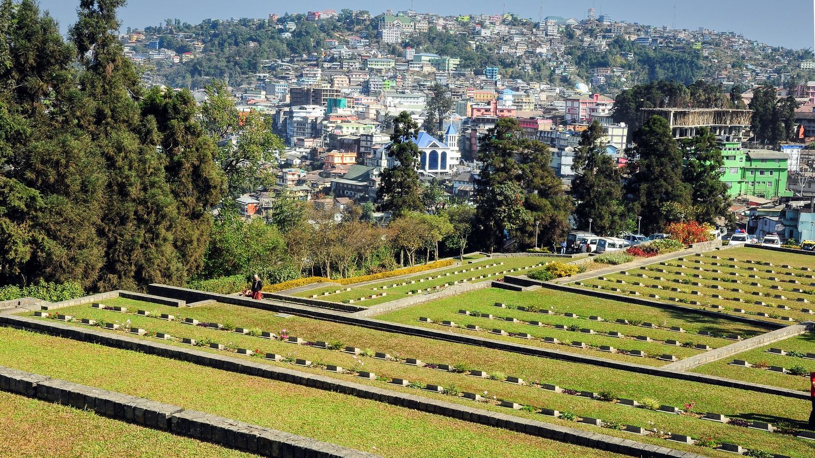
Photo: Kanad Sanyal, CC BY-SA 4.0 (cropped), via Wikimedia Commons

Kohima spread along its ridges, late on a clear winter afternoon.
Nagaland has no big city, only towns, and each one is the market and meeting place of a people.
Kohima, the capital on the ridges
Kohima is the seat of government, but it is not the largest town. The 2011 Census counted 99,039 people in its municipal area, spread over ridges in the south of the state. For visitors it is the natural base. Kisama, where the Hornbill Festival is held, is a short drive south, the Angami village of Khonoma is 25 km away, and the walks into the Dzukou Valley start from villages south of the town.
No train reaches Kohima yet. Northeast Frontier Railway is building a line from Dhansiri, near Dimapur, to Zubza, near Kohima, and its target for the whole line is 2029. Until then, the way up is the 74 km road from Dimapur, by shared taxi, bus or hired car.
Dimapur and Chumoukedima, the gateway in the plains
Dimapur is the biggest town in Nagaland, with 122,834 people in the 2011 Census. It lies on flat land by the Assam border and holds the state's only civil airport and its main railway station. One place there deserves an hour: the ruins of the Kachari Rajbari, rows of carved sandstone pillars with rounded, mushroom-shaped tops, left by the Dimasa Kachari kingdom and now protected by the Archaeological Survey of India.
Chumoukedima, where the Kohima road starts to climb, is now a district town of its own. Shokhuvi, on the new line towards Kohima, became the state's second passenger station in 2022, with trains to Guwahati.
Wokha, Mokokchung and Zunheboto, the middle hills
North of Kohima, the road runs 80 km to Wokha, the main town of the Lotha Nagas, and on to Mokokchung, 152 km from Kohima by that route. Wokha is the town for the Doyang reservoir, where flocks of migrating Amur falcons roost in October and November. Mokokchung is the centre of Ao Naga life and the main market of the Ao hills. About 17 km away, Longkhum is the highest Ao village, at 1,846 m; the Ao believe it is where the spirits of the dead rest on their way onward.
Zunheboto, about 150 km from Kohima, is the Sumi Naga town. All three are small: in 2011 they had between about 22,600 and 35,900 people each. Mokokchung is often easier to reach from Assam than from Kohima. The district puts Jorhat airport about 110 km away and Mariani railway station about 85 km.
Mon, Tuensang and the eastern hills
Mon is the Konyak Naga town in the far north-east, and the base for Longwa, 45 km further on, a village that the Myanmar border runs through. Mon is about 60 to 65 km from Sonari, whose nearest railway station is Bhojo, and about 161 km from Jorhat airport. Night buses also run from Dimapur. Allow a full day each way.
Tuensang was the largest town of the eastern hills in 2011, with 36,774 people. Tuensang, Kiphire, Longleng and the newer eastern districts see few visitors; roads are long and rooms are few, so go with a local operator. Every Indian visitor from outside the state needs a Nagaland Inner Line Permit, for Dimapur too, and foreign visitors need a Protected Area Permit.
Two ways round the north
Nagaland's hill roads do not join up neatly, and the quickest way between two Naga towns is sometimes through Assam. From Kohima, Mokokchung is 152 km by the hill road through Wokha, or 345 km by the longer road through Jorhat and Tuli. The state lists Mon at 336 km from Kohima by way of Mariani in Assam.
A practical week: two or three nights in Kohima, a day's drive north to Mokokchung through Wokha, then down to the Assam plains and across to Sonari and up to Mon. Fly home from Jorhat or Dibrugarh. Keep your Inner Line Permit with you throughout, since this route leaves Nagaland and enters it again.
Towns to know
- Kohima (Kohima): the capital, 99,039 people in the 2011 Census; the base for Kisama, Khonoma and Dzukou.
- Dimapur (Dimapur): the largest town, 122,834 in 2011; the airport, the main station and the Kachari ruins.
- Chumoukedima (Chumoukedima): the foot of the Kohima road, now a district town.
- Wokha (Wokha): the Lotha town, for Doyang and the falcons in autumn.
- Mokokchung (Mokokchung): the Ao town, with Longkhum village about 17 km away.
- Zunheboto (Zunheboto): the Sumi town in the central hills.
- Mon (Mon): the Konyak town, reached through Sonari in Assam; Longwa is 45 km on.
- Tuensang (Tuensang): the eastern hills' biggest town in 2011, with 36,774 people.
- Phek (Phek): the Chakhesang town of the south-east; Dzukou is not here but south of Kohima.
Nagaland's towns are small, but behind each one stands a whole country of villages.
Plan your visit
| Best season | October to May, when the roads are driest. The Amur falcons gather around Doyang in October and November, and the Hornbill Festival runs at Kisama from 1 to 10 December. The monsoon months, June to September, close roads with landslides. |
|---|---|
| How to reach | Dimapur has the state's only civil airport and its main railway station; Kohima is 74 km up the road. For Mokokchung, Jorhat airport (about 110 km) and Mariani station (about 85 km) in Assam are closer. For Mon, go through Sonari in Assam, with Bhojo the nearest station. |
| Getting around | Shared Sumos (shared jeeps) and buses link the district towns, and day and night buses run from Dimapur to Mokokchung and Mon. For villages off the bus routes, hire a car and driver. Most moves between districts take a full day. |
| Where to stay | Central Kohima as a base; Dimapur near the station for a night in transit; Mokokchung town for the Ao hills; Mon town, or homestays in Longwa. |
| How long to spend | Three or four days for Kohima and Dimapur; a week to add Wokha and Mokokchung; ten days with Mon. The Nagaland guide has the festivals and food. |
| Permits | Indian visitors from outside Nagaland need an Inner Line Permit from ilp.nagaland.gov.in, also for Dimapur: ₹200 for 30 days for a domestic tourist, as of October 2026. Foreign nationals apply for a Protected Area Permit on e-FRRO and register within a day of arriving; the ILP portal also lists a ₹500 foreigner permit. Check both before you go. |
Questions people ask
Which is the biggest city in Nagaland?
Dimapur, with 122,834 people in the 2011 Census, against 99,039 in Kohima. Kohima is the capital; Dimapur is the commercial town and transport hub. The 2027 Census, now under way, will give newer figures.
Is there an official list of Nagaland's most developed cities?
No. No government body ranks Nagaland's towns that way, so this guide does not either. It describes each town by what a visitor finds there and how to reach it.
How do I get to Mon and Longwa?
Most people go through Assam: by train to Bhojo, or by air to Jorhat or Dibrugarh, then by road through Sonari, about 60 to 65 km from Mon. Longwa is 45 km beyond Mon. Night buses also run from Dimapur.
Read next
Written by Muthu, editor of Aura of India. Sources: Northeast Frontier Railway: progress on the Dimapur (Dhansiri) to Kohima (Zubza) line, Press Information Bureau: rail connectivity in the North East (Shokhuvi, Kohima line targets), DIPR Nagaland: road distances from Kohima, DIPR Nagaland: other important routes (Mon, Longwa, Sonari), District Mon: How to reach, District Mokokchung: How to reach, District Mokokchung: Longkhum Village, District Dimapur: Kachari Ruins, Nagaland Inner Line Permit portal: fees. Last verified: 15 October 2026.
Your turn: Did you reach Mon through Sonari in Assam or over the hills from Mokokchung, and how long did the road take?
Comments
Post a Comment
Comments are always welcome, that will help us to motivate ourselves and improve our services. Thanks!!