Cities and Towns in Tripura: Agartala, Udaipur, Dharmanagar
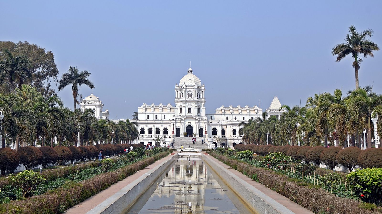
Photo: Kingshuk Mondal, CC BY 4.0 (cropped), via Wikimedia Commons

The Jagannath temple in the palace grounds at Agartala, late afternoon, reflected in the pond in front of it.
Tripura has one city and a string of small towns, and a single railway line joins almost all of them.
Agartala, the only city
Agartala is the capital and the only city of any size. The 2011 Census counted 400,004 people there; the next largest town, Dharmanagar, had about 41,000. It sits on low ground at the state's western edge, so close to Bangladesh that the border runs along the edge of town. The centre is the white Ujjayanta Palace, built for the Manikya kings around 1901 and now the state museum, with the Jagannath temple and its pond in the grounds. A ticket is now needed for the museum; check the rate at the gate. Old Agartala, at Khayerpur, a short drive east, has the temple of the Fourteen Gods.
Maharaja Bir Bikram Airport is about 12 km north-west of the centre, with flights from Kolkata, Guwahati, Delhi and other cities. The railway station is at Badharghat, south of the centre, with trains from Guwahati, Kolkata and Delhi. Autos and e-rickshaws do the short trips. The Akhaura check post on the western edge of the city is the land crossing into Bangladesh for travellers with a visa.
Udaipur, Melaghar and Amarpur, the towns of the south-centre
Udaipur was the old royal capital before Agartala. It is a quiet town of large old tanks, and the base for the Tripura Sundari temple at Matabari, one of the 51 seats of the goddess. Local trains reach it from Agartala in about three-quarters of an hour, so it makes an easy day trip.
Melaghar, west of Udaipur, is the small town on Rudrasagar Lake, where boats leave for the Neermahal water palace. Amarpur, east of Udaipur on the Gomati river, is the starting point for the boat ride to the cliff carvings at Chabimura. With a hired car, Udaipur and Melaghar fit into one long day from Agartala; Chabimura needs another.
Belonia and Sabroom, the southern border towns
Belonia sits on the Muhuri river at the Bangladesh border. It is the nearest town to Pilak, where old Buddhist and Hindu stone images lie scattered across the fields. Sabroom is the end of the line, 109 km from Agartala and about two and a quarter hours by local train. Here the Feni river is the border, and the 1.9 km Maitri Setu bridge, opened in 2021, crosses it to Ramgarh in Bangladesh. Bangladesh's port of Chittagong is only about 80 km beyond. The check post at the bridge is still not open to travellers, so Sabroom is, for now, a place to see the river and turn back.
Ambassa, Kailashahar and Dharmanagar, the north
The road north from Agartala climbs over forested ridges to Ambassa, a small hill town and the headquarters of Dhalai district, halfway up the state. Kailashahar, near the Bangladesh border in the north, is the nearest town to Unakoti, where giant faces of Shiva and other gods are carved into a forest hillside. Dharmanagar is the northern railhead, about 140 km from Agartala and between two and a half and five hours by train. It is the base for the drive up to the orange orchards of the Jampui Hills.
Travelling the state by train
One line runs the length of Tripura, from Dharmanagar through Agartala to Sabroom. Local trains leave Agartala for Sabroom four times a day, stopping at Udaipur (about 45 minutes) and Belonia (about 1 hour 15 minutes). Northbound, Dharmanagar takes from about 2 hours 40 minutes to nearly 5 hours.
The trains are cheap and simple, but the sights are not at the stations. For how the eight districts divide the state, read Tripura's eight districts.
Crossing to Bangladesh
The Akhaura check post at Agartala is the working land crossing, for travellers with a Bangladesh visa. The Agartala–Akhaura railway and the Maitri Setu check post at Sabroom are built but not in use. Border rules change with relations between the two countries, so check before you go.
Cities to know
- Agartala (West Tripura): the capital; 400,004 people (Census 2011), the palace museum, the airport and the main station.
- Udaipur (Gomati): the old capital and the Tripura Sundari temple, under an hour by train.
- Melaghar (Sipahijala): the town on Rudrasagar Lake, for Neermahal.
- Amarpur (Gomati): the start of the boat ride to Chabimura.
- Belonia (South Tripura): a border town near the ruins of Pilak.
- Sabroom (South Tripura): the end of the railway and the Maitri Setu bridge.
- Ambassa (Dhalai): a hill town halfway north on the main road.
- Kailashahar (Unakoti): the nearest town to the Unakoti carvings.
- Dharmanagar (North Tripura): the northern railhead, with 40,595 people (Census 2011), and the way to the Jampui Hills.
Ride the line from Dharmanagar down to Sabroom and you cross almost the whole of Tripura between breakfast and dusk.
Plan your visit
| Best season | October to March, when it is dry and mild. The monsoon, from about June to September, is hot, humid and wet. |
|---|---|
| How to reach | Maharaja Bir Bikram Airport, Agartala, with flights from Kolkata, Guwahati, Delhi and other cities. Trains from Guwahati, Kolkata (Sealdah) and Delhi to Agartala; some long-distance trains run on to Sabroom. |
| Getting around | Local trains along the north-south line; buses and shared taxis between towns; a hired car for Neermahal, Chabimura, Unakoti and the Jampui Hills. Autos and e-rickshaws inside Agartala. |
| Where to stay | Central Agartala near Ujjayanta Palace; Udaipur for Matabari; Melaghar for Neermahal; Kailashahar or Dharmanagar for Unakoti and the north. |
| How long to spend | Two days for Agartala, a day for Udaipur and Melaghar, a day for Chabimura, and two for Kailashahar, Unakoti and Dharmanagar. More in our Tripura guide. |
| Permits | None for Indian visitors, and no special permit for foreign visitors with a valid visa. Carry your passport near the border. |
Questions people ask
Which is the most developed town in Tripura?
There is no official ranking of 'developed' towns. Agartala is the only city: it had 400,004 people in 2011, about ten times as many as Dharmanagar, the next largest. It has the airport, the main station and most hotels.
Is Udaipur in Tripura the same as Udaipur in Rajasthan?
No. Tripura's Udaipur is a small town 43 km south of Agartala by rail. Railway booking sites list its station as Udaipur Tripura, so check the name before you book.
Can I see Tripura's towns without a car?
Partly. Trains reach Udaipur, Belonia, Sabroom and Dharmanagar. Neermahal, Chabimura, Unakoti and the Jampui Hills need a car or shared taxi from the nearest town.
Read next
Written by Muthu, editor of Aura of India. Sources: Ministry of External Affairs: Maitri Setu between India and Bangladesh (2021), Tripurainfo: Maitri Setu, border haats and the Agartala–Akhaura rail link await operation (2026), Dhaka Tribune: Akhaura–Agartala railway lies idle, Government of Tripura: places of interest, erail: trains between Agartala and Sabroom, City Population: Tripura towns, Census 2011. Last verified: 15 October 2026.
Your turn: Have you taken the local train south from Agartala? Where did you get off, and what did you find there?
Comments
Post a Comment
Comments are always welcome, that will help us to motivate ourselves and improve our services. Thanks!!