Cities in Jharkhand: Ranchi, Jamshedpur, Dhanbad, Deoghar Guide
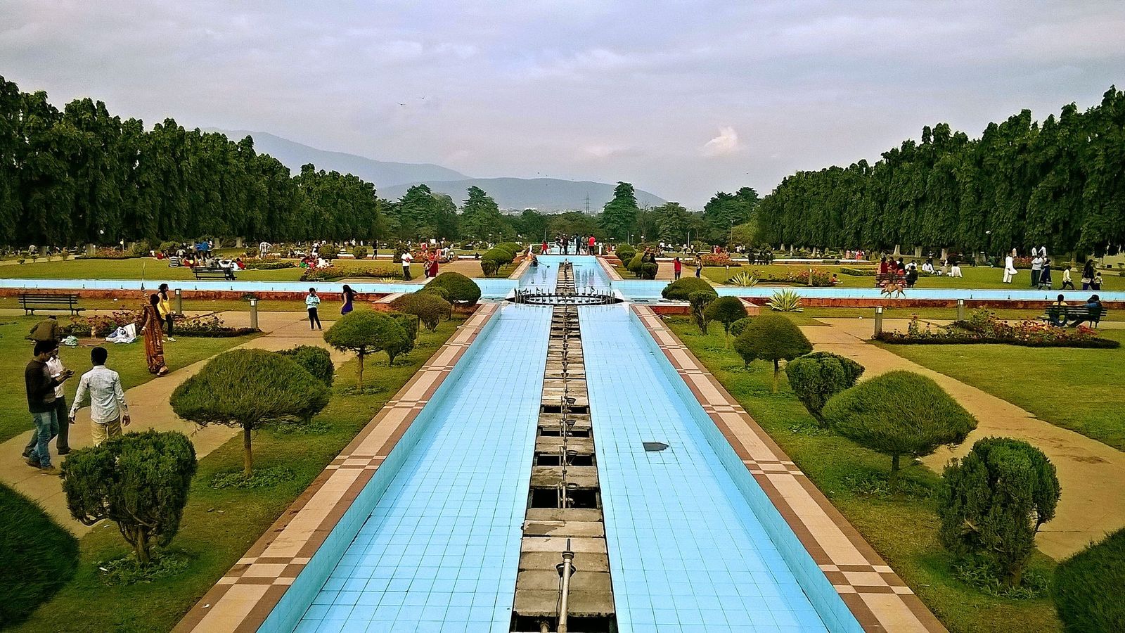
Photo: Mohitjamshedpurian, CC BY-SA 4.0 (cropped), via Wikimedia Commons

Jubilee Park in Jamshedpur on a winter evening, with the Dalma hills dark to the north.
Jharkhand's cities were built for government, steel and coal, and the forest and waterfalls begin where their streets run out.
Ranchi, the capital on the plateau
Ranchi sits on the Chota Nagpur plateau, and under British rule it was the summer capital of Bihar, chosen for its milder air. It became the capital of Jharkhand when the state was formed in 2000. The city itself is mostly offices, colleges and markets, but it has two easy viewpoints: Pahari Mandir, a Shiva temple on a hill reached by a long flight of steps, and Tagore Hill in Morabadi, where Jyotindranath Tagore, the poet's elder brother, built a retreat. The Rock Garden lies beside Kanke dam, about 4 km from Albert Ekka Chowk in the centre.
Most visitors use Ranchi as a base for the waterfalls: Dassam about 34 km out on the Jamshedpur road, Jonha about 40 km, and Hundru about 45 km off the Purulia road. They are fullest after the monsoon, from August to October. Birsa Munda Airport has the state's widest choice of flights.
Jamshedpur, the steel town
Jamshedpur is the largest urban area in Jharkhand, with about 1.3 million people at the 2011 Census. It was laid out from 1908 around Tata's steel works at Sakchi, where the Subarnarekha and Kharkai rivers meet, and named after Jamsetji Tata in 1919, when Kalimati station also became Tatanagar. It is still a company town in feel, with wide roads, numbered sectors and parks. Jubilee Park, gifted to the city in 1958, is the place to walk, and Dimna Lake lies under the Dalma hills just outside. The steel works itself is not open to casual visitors.
Ranchi is about 130 km away by road, two and a half to three hours, or a little over three hours on the morning Vande Bharat. Chaibasa, to the south-west, is the way into the sal forests of Saranda.
Dhanbad, Bokaro and Ramgarh, the coal belt
Dhanbad, in the east of the state, is India's best-known coal town. The fires under Jharia, on its edge, have burned since 1916, and the Indian School of Mines, founded in 1926, became an IIT in 2016. Bokaro Steel City, to the west, grew around a public-sector steel plant built with Soviet help; its first blast furnace was lit in 1972. Neither city has scheduled flights; come by train or from Ranchi.
Ramgarh, between Ranchi and Hazaribagh, is a cantonment and coal town. Its reasons to stop are nearby: the Chhinnamastika temple at Rajrappa, where the Bhairavi river meets the Damodar, about 28 km away, and Patratu dam, about 30 km west.
Deoghar, Hazaribagh and Giridih
Deoghar grew around the Baidyanath temple, one of Shiva's twelve jyotirlinga shrines, and in Shravan, in July and August, it fills with pilgrims who walk there from the Ganges in Bihar; Jharkhand's temples tells that story. The town now has an airport with flights to Delhi, Kolkata, Bengaluru and Mumbai.
Hazaribagh is a quieter town of lakes and low hills, with Canary Hill about 3 km from the centre and a wildlife sanctuary, notified in 1954, just to the north. The district is known for Sohrai and Khovar wall painting, which received a GI tag in 2020. Giridih, to the east, is the base for Parasnath hill, where Jains believe twenty of their twenty-four tirthankaras, or teachers, attained liberation. Gumla, often listed with these towns, is mainly the way to Tanginath Dham and Anjan.
Planning a route
The cities sit far apart, and most trips are built around one or two of them. Ranchi and Jamshedpur pair easily by road or the morning train. Deoghar is a separate trip, usually by air or from the Bihar side by rail through Jasidih. Hazaribagh, Ramgarh and Rajrappa fit into a loop north of Ranchi.
Distances on the map look short, but many roads are two-lane and pass through mining traffic. Travel by day, and keep the evenings for the towns themselves.
Cities to know
- Ranchi (Ranchi): the capital, the airport and the waterfalls; about 1.1 million (2011 Census, urban area).
- Jamshedpur (East Singhbhum): the steel town, Jubilee Park and Dalma; about 1.3 million (2011 Census).
- Dhanbad (Dhanbad): coal, Jharia and IIT (ISM); about 1.2 million (2011 Census).
- Bokaro Steel City (Bokaro): the planned steel township.
- Deoghar (Deoghar): Baidyanath Dham and the Shravan pilgrimage.
- Hazaribagh (Hazaribagh): lakes, Canary Hill and Sohrai painting.
- Ramgarh (Ramgarh): the stop for Rajrappa and Patratu.
- Giridih (Giridih): the road to Parasnath.
- Chaibasa (West Singhbhum): the edge of Saranda forest.
In Jharkhand the chimneys and the forest are never far apart, and most journeys pass both.
Plan your visit
| Best season | October to February, when it is cool and dry. April to June is hot on the plateau; the waterfalls are fullest from August to October. |
|---|---|
| How to reach | Birsa Munda Airport, Ranchi, has the most flights; Deoghar also has an airport. Main stations: Ranchi, Hatia, Tatanagar (Jamshedpur), Dhanbad, Bokaro Steel City and Jasidih for Deoghar. |
| Getting around | Hired cars or app cabs for day trips to the waterfalls and Dalma; buses link the cities, and auto-rickshaws work within them. |
| Where to stay | Main Road or near the station in Ranchi; Bistupur or Sakchi in Jamshedpur; Bank More in Dhanbad; near the temple or Castairs Town in Deoghar. |
| How long to spend | Two days in Ranchi with the falls, one or two in Jamshedpur, a day each for Deoghar and Hazaribagh. More in our Jharkhand guide. |
Questions people ask
Which is the biggest city in Jharkhand?
Jamshedpur's urban area was the largest at the 2011 Census, about 1.3 million, ahead of Dhanbad and Ranchi. There is no official ranking of the state's cities by development.
How do I get from Ranchi to Jamshedpur?
By road it is about 130 km, two and a half to three hours. The Vande Bharat leaves Ranchi early in the morning and reaches Tatanagar in a little over three hours; check the current timetable.
Can I fly to Dhanbad or Bokaro?
Not at present. Neither airport has scheduled flights; use Ranchi, or Deoghar for the north-east of the state, and continue by train or road.
Can I visit the Tata steel works?
Not casually. The plant is a working site with restricted entry; check with Tata Steel before you go if a visit matters to you.
Read next
Written by Muthu, editor of Aura of India. Sources: Census of India 2011: Urban agglomerations and cities of one million and above (provisional), District Ranchi: tourism, Tata Steel: Jamshedpur brochure, District East Singhbhum: tourist places, IIT (ISM) Dhanbad: history, SAIL: About Bokaro Steel Plant, District Ramgarh: tourist places (Chhinnamastika temple, Patratu dam), District Hazaribag: Canary Hill, District Khunti: Angrabari Shiv temple. Last verified: 15 October 2026.
Your turn: Which Jharkhand city would you pair with Ranchi, and why?
भोसरी के
ReplyDelete