Cities in Uttarakhand: Dehradun, Haridwar, Rishikesh, Haldwani
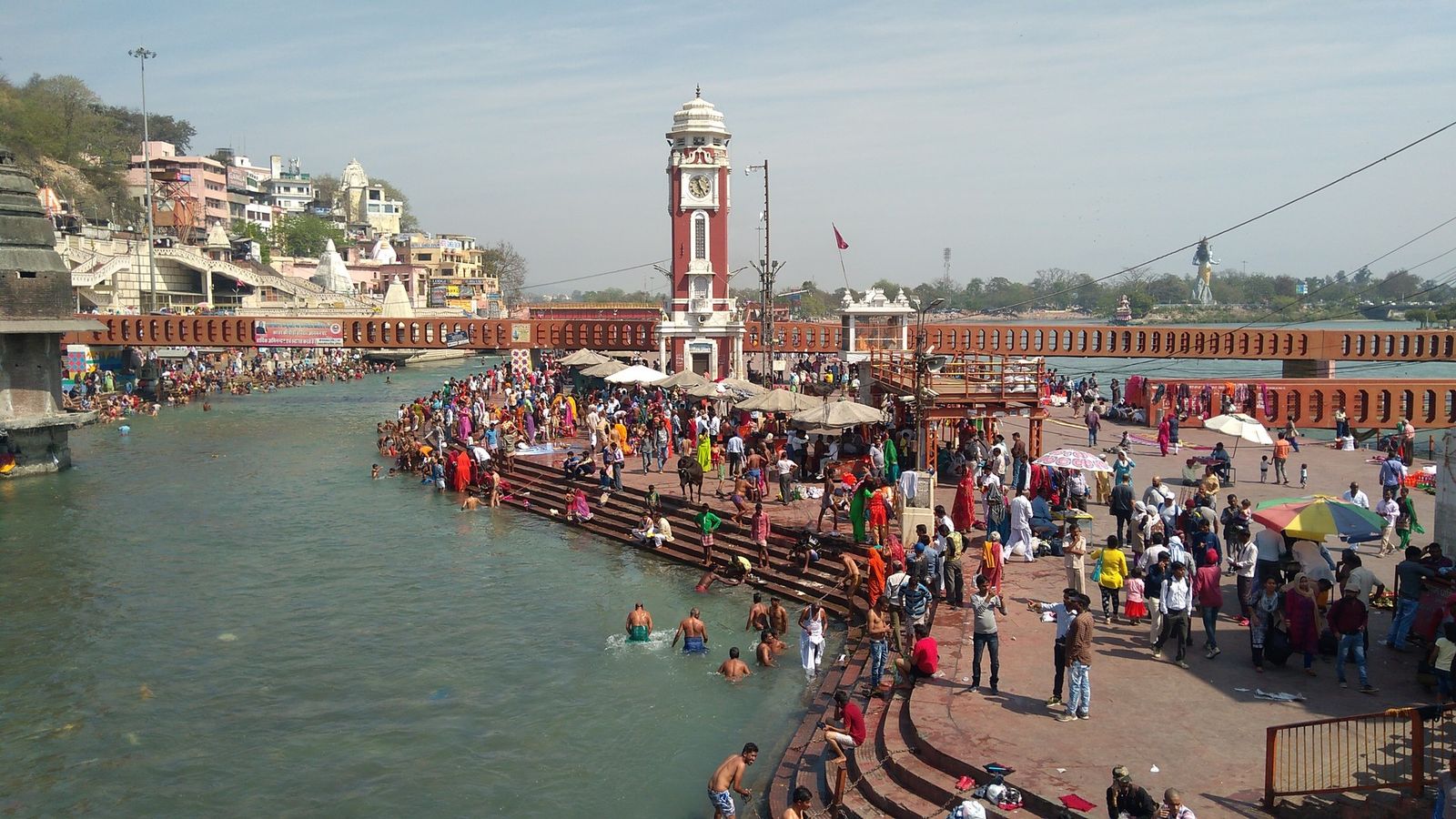
Photo: आशीष_भटनागर, CC BY-SA 3.0 (cropped), via Wikimedia Commons

Har ki Pauri in Haridwar, early evening, as the crowd gathers on the steps above the Ganga.
Uttarakhand's cities sit where the plains meet the hills, and almost every journey into the mountains begins in one of them.
Dehradun, the capital in the Doon
Dehradun lies in the Doon, a wide valley between the low Shivalik hills and the first ranges of the Himalaya. It is the capital and the largest city: the 2011 Census counted 578,420 people in the municipal corporation. It is a spread-out place of schools and institutes rather than sights. The one to see is the Forest Research Institute, a long red-brick colonial building in a wooded campus. It reopened in May 2026 with higher tickets: ₹100 for Indian and ₹1,000 for foreign visitors.
The Delhi–Dehradun Expressway, opened in April 2026, cuts the drive from Delhi to about two and a half hours on a good day. Jolly Grant airport lies south-east of the city, on the road to Rishikesh. Mussoorie sits on the ridge above, a winding drive uphill.
Haridwar, Rishikesh and Roorkee, the Ganga cities
Haridwar is where the Ganga leaves the hills for the plain. It is a city of ghats, ashrams and pilgrims, and Har ki Pauri, with its evening aarti, is its centre. It is also the rail junction for the shrine roads. Expect big crowds from January to April 2027, during the Ardh Kumbh.
Rishikesh, a short drive upstream, is greener and quieter, spread along both banks where the river is still fast and clear. For now Bajrang Setu, a new suspension bridge with glass walkways, is the main way across on foot in the ashram area. The old Lakshman Jhula beside it has been closed since 2022, and Ram Jhula has been shut for repairs since July 2026. Roorkee, on the railway from Delhi, is rarely on a visitor's list. But it is where the Ganga Canal crosses the Solani river on a long aqueduct, and where India's first engineering college was founded in 1847 to train the canal's engineers. It is now IIT Roorkee.
Haldwani, Rudrapur and Ramnagar, the Kumaon plains
In the east, the cities of the Terai, the flat strip of land below the Kumaon hills, are working towns. Haldwani and its twin Kathgodam are the gateway to the hills: Kathgodam station is the end of the line, and taxis and buses wait there for Nainital, Bhimtal and Almora. Rudrapur grew fast around the industrial estates near Pantnagar, which also has the region's airport. Ramnagar, smaller, is the town at the gates of Corbett National Park. Few visitors stay in these towns; most change from train to taxi and go straight up the hill.
Nainital, Almora, Pithoragarh and Srinagar, the towns in the hills
The hill towns are small, and some are steep enough that walking is the only way to see them. Nainital wraps round its lake, with the Mall on one side and the state's High Court above it. Almora sits along a ridge, an old Kumaoni town of stone-paved lanes and carved wooden houses. Pithoragarh, near the Nepal border, is the last town of any size on the roads to Munsiyari and Dharchula.
In Garhwal, Srinagar (not the one in Kashmir) is a university town on the Alaknanda, on the road to Badrinath. The Rishikesh–Karnaprayag railway will pass through it; its builders aim to finish by December 2029.
Rishikesh's bridges and the coming railway
Bajrang Setu joins Tapovan with Jonk across the river. The glass walkways are open from 6 am to 10 pm, and the concrete path down the middle is free. The state has approved a charge for the glass, to start once a contractor is chosen. Ram Jhula is due to reopen by early 2027; check before you go.
The Rishikesh–Karnaprayag line is 125 km long and runs mostly through tunnels. In August 2026 it was 78 per cent complete. Until it opens, the road is the only way to the shrines.
From Delhi to the hills by way of the cities
For Garhwal, go from Delhi to Dehradun or Haridwar, see Rishikesh between them, and start for the hills from there. For Kumaon, take the train to Kathgodam and go straight up to Nainital and Almora. For how the two regions differ, read Uttarakhand, Garhwal and Kumaon.
Cities to know
- Dehradun (Dehradun): the capital; 578,420 people in the municipal corporation (Census 2011).
- Haridwar (Haridwar): Har ki Pauri and the rail junction for the shrine roads.
- Rishikesh (Dehradun, Tehri Garhwal and Pauri Garhwal): ashrams, yoga and the new Bajrang Setu.
- Roorkee (Haridwar): the canal town and IIT Roorkee.
- Haldwani and Kathgodam (Nainital): the railhead for the Kumaon hills.
- Rudrapur (Udham Singh Nagar): an industrial town near Pantnagar airport.
- Nainital (Nainital): the lake town and the High Court.
- Almora (Almora): a ridge town of stone lanes.
- Pithoragarh (Pithoragarh): the base for Munsiyari and Dharchula.
- Srinagar (Pauri Garhwal): a university town on the Alaknanda, on the Badrinath road.
In Uttarakhand the city is rarely the place you came for; it is the last flat ground before the road starts to climb.
Plan your visit
| Best season | October to March for the plains cities; March to June and September to November for the hill towns. July and August bring landslides on hill roads. |
|---|---|
| How to reach | Jolly Grant airport (Dehradun) for Garhwal; Pantnagar for Kumaon. Stations at Dehradun, Haridwar, Yog Nagari Rishikesh, Roorkee and Kathgodam. |
| Getting around | Shared autos and e-rickshaws in the cities; taxis and state buses between them and up to the hill towns. |
| Where to stay | Rajpur Road in Dehradun; near Har ki Pauri in Haridwar; Tapovan in Rishikesh; the Mall in Nainital; central Almora. |
| How long to spend | A day for Dehradun, two or three for Haridwar and Rishikesh, and three or four for Nainital and Almora. More in our Uttarakhand guide. |
| Permits | None for the cities. Pilgrims going on to the Char Dham or Hemkund Sahib must register online first. |
Questions people ask
Which is the most developed city in Uttarakhand?
There is no official list of 'developed' cities. Dehradun is the capital and the largest, with 578,420 people in its municipal corporation in 2011; Haridwar came next, with 225,235.
Is Lakshman Jhula open in Rishikesh?
No. It has been closed since April 2022 as unsafe. Use Bajrang Setu, the new bridge beside it.
How long does the drive from Delhi to Dehradun take now?
About two and a half hours in good traffic on the expressway opened on 14 April 2026.
Is there a train to Rishikesh?
Yes, to Yog Nagari Rishikesh station. The line on into the hills, to Karnaprayag, is due in December 2029.
Read next
Written by Muthu, editor of Aura of India. Sources: Prime Minister's Office: Delhi–Dehradun Economic Corridor inaugurated (14 April 2026), IIT Roorkee: history of the institute, Indian Express: Rishikesh–Karnaprayag rail project set for December 2029 (August 2026), NDTV: Bajrang Setu glass skywalk opens, fee and timings (2026), Times of India: FRI reopens with new entry fees (May 2026), Amar Ujala: Ram Jhula repair work 55 per cent complete (October 2026), Urban Development Department, Uttarakhand: urban census 2011. Last verified: 15 October 2026.
Your turn: Have you crossed Bajrang Setu in Rishikesh? Did you walk on the glass or keep to the middle?
Best Place to live in Uttarakhand>>>>> Click Here
ReplyDelete