Karnataka's Three Landscapes: Coast, Coffee Hills and the Deccan
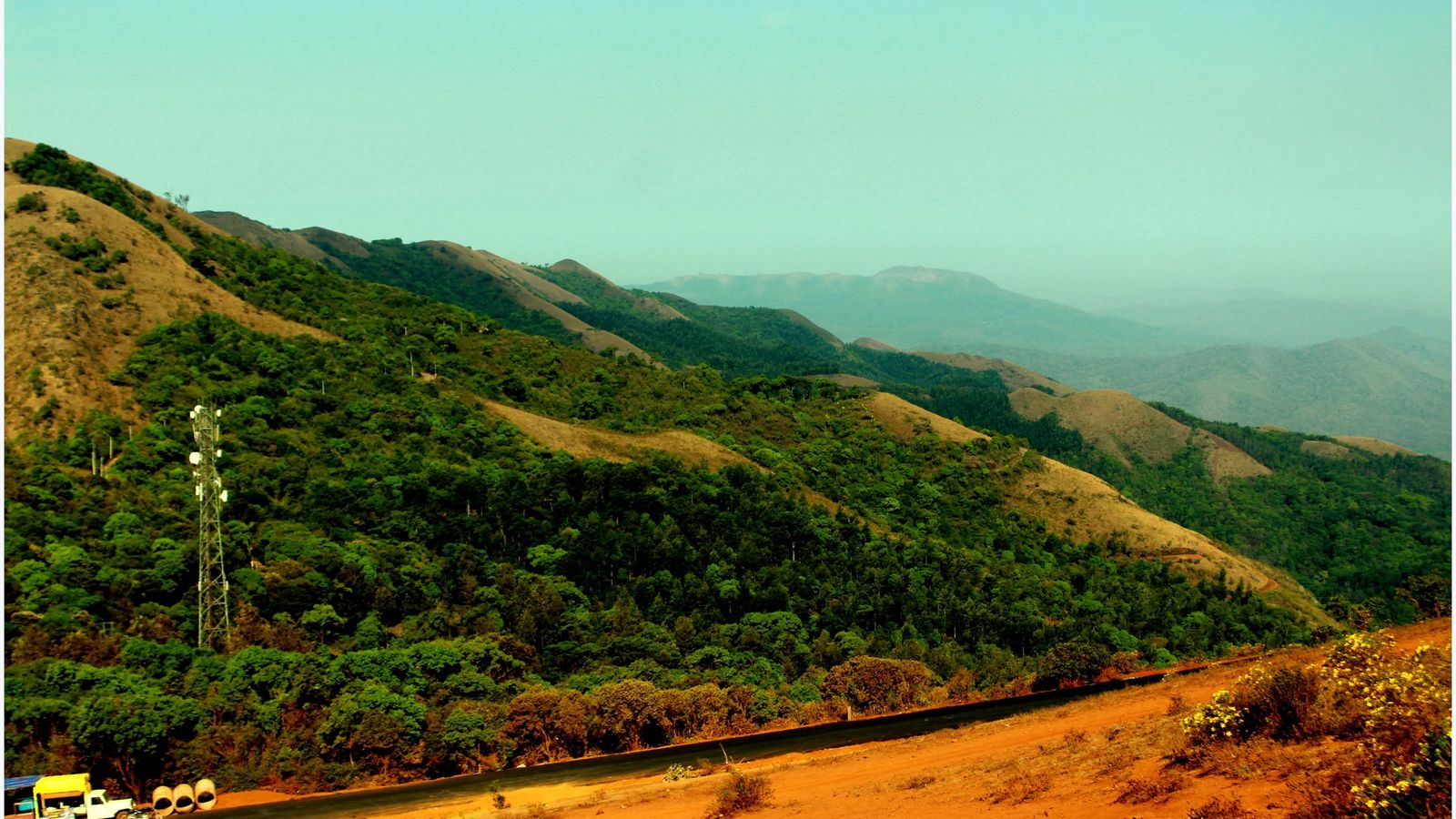
Photo: Nagmys12, CC BY 4.0 (cropped), via Wikimedia Commons

Karnataka in October, as the monsoon leaves the coast and the hills.
Karnataka changes at the ghats: a wet coast, then coffee hills, then a plateau of stone.
Three landscapes in one state
Karnataka runs from the Arabian Sea into the middle of the Deccan. The coast comes first, a narrow strip of rivers, coconut palms and red laterite, with towns such as Mangaluru, Udupi and Gokarna. Behind it rise the Western Ghats, the long line of hills that catches the monsoon. Kannada speakers call this belt the malnad, the hill country: forest, rain, pepper vines and coffee under shade trees. Over the top, the land opens out. The plateau to the east is drier and wider, with granite boulders at Hampi, red sandstone cliffs at Badami and dark stone domes at Vijayapura.
Coffee in the hills
The hills work for a living. Karnataka grows most of India’s coffee, almost all of it in three districts: Kodagu, also called Coorg, Chikkamagaluru and Hassan. Arabica grows on the higher slopes and robusta lower down, both under tall shade trees, with pepper, cardamom and areca nut planted in between. The Coffee Board calls the Baba Budan hills, above Chikkamagaluru, the birthplace of coffee in India. The story goes that a pilgrim named Baba Budan brought seven beans back from Yemen and planted them there. Many estates now take guests in homestays, rooms in the planter’s own house.
Why people come
Most of Karnataka’s history stands on the plateau. The early Chalukya kings cut cave temples into the cliffs at Badami and built the stone temples of Pattadakal. The Hoysalas carved Belur and Halebidu in the twelfth century. Hampi was the capital of the Vijayanagara empire until its defeat in 1565. Then the Adil Shahi sultans of Bijapur, now Vijayapura, raised Gol Gumbaz, a tomb under one of the largest domes ever built. In the south, the Wadiyar kings ruled from Mysuru until independence. The state took its present shape on 1 November 1956, as Mysore State, and was renamed Karnataka in 1973.
Getting there and around
Kempegowda International Airport, outside Bengaluru, is the main gateway. Mangaluru serves the coast, Hubballi and Belagavi the north-west, and Mysuru has a small airport with flights to Chennai and Hyderabad. Vijayapura’s new airport is not open yet; officials hope for early 2027. Trains reach most towns. The Konkan Railway runs along the coast, and trains link Bengaluru with Mysuru, Hassan and Hosapete, the station for Hampi. Distances are long, so choose one region and hire a car with a driver.
One region at a time
The hills make the easiest first trip. Four or five days around Chikkamagaluru give time for an estate stay, a morning on Mullayanagiri and a day at the Hoysala temples of Belur and Halebidu, about an hour’s drive away. Kodagu is a separate trip, reached from Mysuru, with Madikeri as its main town.
The plateau needs a week. Spend two or three days at Hampi, then move north-west to Badami, where Aihole and Pattadakal are close enough for day trips. Vijayapura can end the journey. The coast is best from November, once the sea has calmed after the rains: Udupi for its temple and food, Gokarna for quieter beaches, the Konkan Railway between them.
Vijayapura and the north
Few visitors get as far as Vijayapura, and the city is quieter for it. Gol Gumbaz, the tomb of Mohammed Adil Shah, who ruled Bijapur in the seventeenth century, is its centre. The district calls its dome the second largest ever built, after St Peter’s in Rome. A gallery runs round the inside of the dome, and a whisper at one side can be heard clearly about 37 metres away.
Entry is ticketed by the Archaeological Survey of India; check the fee at the gate. Until the new airport opens, come by train, or by road from Belagavi or Hubballi. For more of the state, see the Karnataka guide.
Places to know
- Mysuru: the old royal city, its palace lit every evening during Dasara.
- Kodagu (Coorg): coffee estates, homestays and Talakaveri, where the Kaveri river begins.
- Chikkamagaluru: the Baba Budan hills and Mullayanagiri, the highest peak in the state.
- Belur and Halebidu: Hoysala temples carved in soft grey-green stone.
- Hampi: the ruined Vijayanagara capital among granite boulders by the Tungabhadra.
- Badami, Aihole and Pattadakal: Chalukya cave temples and early stone temples.
- Udupi and Gokarna: temple towns on the coast, with beaches close by.
Pick one height and stay there. The coast will keep, and so will the stone.
Plan your visit
| Best season | October to February. The coast and hills are green after the monsoon and the plateau is cool enough to walk. March to May is hot on the plateau; June to September brings heavy rain to the coast and the ghats. |
|---|---|
| How to reach | Fly to Bengaluru (Kempegowda International), Mangaluru, Hubballi, Belagavi or Mysuru. Trains link Bengaluru with Mysuru, Hassan, Hosapete and Hubballi; the Konkan Railway runs along the coast. |
| Getting around | A car with a driver between regions; state-run buses between towns; the Namma Metro in Bengaluru. |
| Where to stay | Central Bengaluru for a first night; the streets around the palace in Mysuru; estate homestays near Madikeri or Chikkamagaluru; Hosapete or Kamalapura for Hampi; Udupi or Gokarna on the coast. |
| How long to spend | A week for one region. Two to three weeks to cross the state from the coast to the plateau. |
| Permits | None to enter the state. Forest treks need an online ticket from the Forest Department’s Aranya Vihaara site, bookable up to 30 days ahead; carry the original ID used to book. On the Kumara Parvatha trail, walkers may only go as far as Shesha Parvatha. |
Questions people ask
Do I need a permit to travel in Karnataka?
No. The state has no entry permit. Forest treks are different: each needs an online ticket from the Forest Department’s Aranya Vihaara site, and the original ID used to book must be shown on the day.
Is October a good time to visit Karnataka?
Yes, for most of the state. The hills and coast are green after the monsoon and the plateau is cooling. Showers are still possible, so keep a day spare.
How many days do I need for Karnataka?
A week covers one region well: the coffee hills with Belur, or Hampi with Badami. Crossing from the coast to the plateau takes two to three weeks.
Is Vijayapura airport open?
Not as of October 2026. The state’s infrastructure corporation hopes to start flights by early 2027. Until then, go by train or by road from Belagavi or Hubballi.
Read next
Written by Muthu, editor of Aura of India. Sources: Coffee Board of India: coffee regions of India, Coffee Board of India: coffee statistics, UNESCO World Heritage Centre: Sacred Ensembles of the Hoysalas, District Vijayapura, Government of Karnataka: Gol Gumbaz, District Bengaluru Urban: Kannada Rajyotsava, The Hindu: Fifty years of ‘Karnataka’, Karnataka Forest Department: Aranya Vihaara trek booking, The Hindu: daytime trekking allowed till Shesha Parvatha, The Hindu: Vijayapura airport by early next year (26 August 2026). Last verified: 15 October 2026.
Your turn: Coast, coffee hills or the plateau: if you had one week in Karnataka, which would you pick, and where would you stay?
Comments
Post a Comment
Comments are always welcome, that will help us to motivate ourselves and improve our services. Thanks!!